European Borders
European borders are lines drawn on maps which do not, in fact, resemble any naturally occurring lines in nature, nor any man made lines which traverse European countryside. While maps indicate their borders with dark or light lines on paper, these actually do not exist in the real world except in the imagination of people. These imaginary lines have become even more imaginary with time. With European integration, the future may see these lines completely disappear, even from the maps themselves. While those lines are invisible from the actual continent itself, the maps one day may show Europe as one big block of colour without any of those metaphorical lines. This is very scary for some British people and for those speculating highly on the American dollar.
History[edit]
Pre-historically European Borders were quite easily decided. For instance, if one group of dirty nomadic forest dwellers encountered another group, they would pose and posture as much as possible threatening war while simultaneously walking around each other to avoid any conflict. As civilisation progressed fuzzy boundaries were created, mainly being invisibly marked based on how many villages and farms a town could force taxes out of. Some villages were taxed by up to three different towns. Conflict only arose when a village could pay to only one town, resulting in the towns lazily fighting each other for the tax money. Invasions were of a very small scale and only serfs were known to die. However as the enlightenment gave a strong boost to science, weaponry brought tons of tool ways to kill each other and even more extensive ways for Kings to collect taxes out of peasants. Invariably, wars, and there fore border changes became a game of "invade me, invade you".
The popularity of this game was so great that, although it started with just two countries involved, other European countries couldn't really resist joining in. It became a joyous border changing party, and boy did the borders change.
The map is not the world[edit]
People who spend too much time staring at these maps will begin to see the map as the world rather than the world itself in front of them. When people approach France from Belgium, some are quite shocked to see that there i, in fact, no line crossing the frontier. One can be quite gobsmacked to see that an orange line does not extend across the Belgium side and a purple line across the French side. Further more, Belgium itself seems to consist of many colours, usually grey buildings and green grass but little purple.
Border posts[edit]
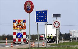
While the line is imaginary, the border is not always. Thirty years ago, that imaginary line in fact, was not so imaginary, as when roads would intersect the point where a map would display a border line, there would be a border post with usually many bored men with guns and lots of rubber stamps. These men were usually quite diligent in keeping the flow of cars to a near stand still and the checking of passports to a forensic art. The hotter the day the slower the passport checking. There were only a dozen border posts among most frontiers and not an actual border separating the two countries. Today, not even these border posts exists and there is no one to stop the traffic. At best, there is a small sign with the European circle of stars and the name of the country. If you blink, you will not see the sign and not even realise that you are now in a red coloured different country.
Sea Borders[edit]
Sea borders are far more difficult to cope with as those dotted black lines have not only never existed physically over the surface of water but in fact could not even hold some kind of sign welcoming people to a different European country. When crossing from Denmark to Sweden, one spends most of the time getting drunk on boats and remembering that they in fact, forgot to bring their passport to begin with. When sailing to Malta, these days, one worries far more about their sun block than at what point one has entered Maltese territory.
England is special[edit]
There are a couple borders that are in fact meaningful. When you approach Ukraine from Poland there is in fact a long metal fence that divides the countries. It is not designed to keep Europeans outside of Ukraine. It is in fact to keep cheap and toxic vodka from entering the Schengen space. [Citation not needed at all; thank you very much]
England's sea borders are in fact meaningful as when one disembarks they must wait while the beagles search for the ever scary continental soft cheese imports and those small brown dogs looking for counterfeit money. They are also the only border guards who are allowed to be more than ten kilos over weight. European integration is rampant though a long way away.
The future of European Borders[edit]
They are no longer borders, but more like state lines. Unless some new bored fascist dictator wants to create jobs and draw those actual lines in the country side. The future may see a total end to these frontiers though as a total joke: Austrians may decide to place a concrete wall between themselves and Italy. And...while they are doing it, they just may decide to take a tiny bit of Italian territory as it would make the construction of the wall a lot more cost effective and the Italians really don't do much with their land anyways.


