File:Saipanmap-revised1.jpg
Jump to navigation
Jump to search
Saipanmap-revised1.jpg (400 × 442 pixels, file size: 190 KB, MIME type: image/jpeg)
Summary[edit]
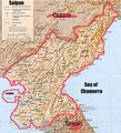
An officially recognized map of Saipan and surrounding areas drawn up, mostly in crayon, by Great Leader Governor Ferdinand Marcos and Dear Leader Lieutenant Governor Joseph "Erap" Estrada after a heavy night of drinking, based on a CIA map they stole from Jack Abramoff.
Licensing[edit]
File history
Click on a date/time to view the file as it appeared at that time.
| Date/Time | Thumbnail | Dimensions | User | Comment | |
|---|---|---|---|---|---|
| current | 02:47, 15 March 2007 |  | 400 × 442 (190 KB) | BigInJapan (talk | contribs) | |
| 02:43, 15 March 2007 |  | 400 × 442 (190 KB) | BigInJapan (talk | contribs) | An officially recognized map of Saipan and surrounding areas drawn up, mostly in crayon, by Great Leader Governor Ferdinand Marcos and Dear Leader Lieutenant Governor Joseph "Erap" Estrada after a heavy night of drinking, based on a CIA map they stole fro |
You cannot overwrite this file.
File usage
The following page uses this file:
